
Datei:Possible definitions of the boundary between Europe and Asia.png
Originaldatei (729 × 1.129 Pixel, Dateigröße: 207 KB, MIME-Typ: image/png)
![]()
Diese Datei und die Informationen unter dem roten Trennstrich werden aus dem zentralen Medienarchiv Wikimedia Commons eingebunden.
![]()
Beschreibung
| Beschreibung |
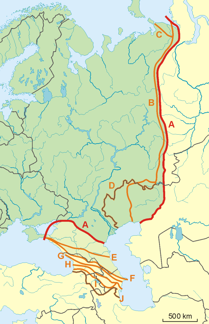
English: A map of possible definitions of the boundary between Asia and Europe.
Note that most of these lines are not referenced to any sources proposing them. The red line marked "A" is apparently the "Strahlenberg" definition commononly taught in Soviet-era Russia. See File:Historical Europe-Asia boundaries 1700 to 1900.png for a map which is actually based on references. The modern mainstream definition used by the UN (see also this) are marked "B" (Urals and Ural River) and "F" (Caucasus watershed). Lines C, D, E, G, H, I and J are currently without reference. Red line - "Strahlenberg" border, allegedly also used by the International Geographical Union [1]
Orange lines - other variants of border:
Polski: Mapa wariantów przebiegów granicy pomiędzy Europą a Azją
linie pomarańczowe - inne warianty przebiegu granicy:
|
| Datum | 09-04-2008 |
| Quelle | Eigenes Werk |
| Urheber | Aotearoa |
| Andere Versionen | Image:TransAsia m.png, File:Historical Europe-Asia boundaries 1700 to 1900.png |
Lizenz

|
Es ist erlaubt, die Datei unter den Bedingungen der GNU-Lizenz für freie Dokumentation, Version 1.2 oder einer späteren Version, veröffentlicht von der Free Software Foundation, zu kopieren, zu verbreiten und/oder zu modifizieren; es gibt keine unveränderlichen Abschnitte, keinen vorderen und keinen hinteren Umschlagtext.
Der vollständige Text der Lizenz ist im Kapitel GNU-Lizenz für freie Dokumentation verfügbar. |
- Dieses Werk darf von dir
- verbreitet werden – vervielfältigt, verbreitet und öffentlich zugänglich gemacht werden
- neu zusammengestellt werden – abgewandelt und bearbeitet werden
- Zu den folgenden Bedingungen:
- Namensnennung – Du musst angemessene Urheber- und Rechteangaben machen, einen Link zur Lizenz beifügen und angeben, ob Änderungen vorgenommen wurden. Diese Angaben dürfen in jeder angemessenen Art und Weise gemacht werden, allerdings nicht so, dass der Eindruck entsteht, der Lizenzgeber unterstütze gerade dich oder deine Nutzung besonders.
- Weitergabe unter gleichen Bedingungen – Wenn du das Material wiedermischst, transformierst oder darauf aufbaust, musst du deine Beiträge unter der gleichen oder einer kompatiblen Lizenz wie das Original verbreiten.
Dateiversionen
Klicke auf einen Zeitpunkt, um diese Version zu laden.
| Version vom | Vorschaubild | Maße | Benutzer | Kommentar | |
|---|---|---|---|---|---|
| aktuell | 10:34, 14. Nov. 2022 | | 729 × 1.129 (207 KB) | Рагин1987 | Dull shade of green up to the "F" line |
| 15:12, 19. Feb. 2022 |  | 729 × 1.129 (205 KB) | Lojwe | Frame removed | |
| 22:29, 1. Okt. 2010 |  | 735 × 1.134 (156 KB) | Bogomolov.PL | Reverted to version as of 08:57, 9 April 2008 | |
| 21:44, 1. Okt. 2010 |  | 735 × 1.134 (137 KB) | Zé Carioca~commonswiki | Trying to fix the error we are facing on the articles. | |
| 17:56, 1. Okt. 2010 |  | 735 × 1.134 (137 KB) | Gvogas | Inclusion of the Miles Clark route line. (sorry for the tries, my internet gave problems). | |
| 17:55, 1. Okt. 2010 |  | 735 × 1.134 (137 KB) | Gvogas | Reverted to version as of 15:52, 1 October 2010 | |
| 17:54, 1. Okt. 2010 |  | 735 × 1.134 (137 KB) | Gvogas | (Inclusion of the Miles Clark route line.) | |
| 17:52, 1. Okt. 2010 |  | 735 × 1.134 (137 KB) | Gvogas | Inclusion of the Miles Clark route line. | |
| 10:57, 9. Apr. 2008 |  | 735 × 1.134 (156 KB) | Aotearoa | {{Information |Description=Map of Europe (green) - Asia (yellow) border. Red line (A) - border accoring to International Geographical Union and most European geographers, orange lines - other variants of border. |Source=własna praca |Date=09-04-2008 | |
Dateiverwendung
Die folgenden 9 Seiten verwenden diese Datei:
- Eurasien
- Liste interkontinentaler Staaten
- Wikipedia:Löschkandidaten/28. Februar 2016
- Wikipedia Diskussion:Kurier/Archiv/2017/10
- Wikipedia Diskussion:Kurier/Archiv/2022/08
- Wikipedia Diskussion:WikiProjekt Geographie/Archiv/2013-1
- Wikipedia Diskussion:WikiProjekt Kategorien/Archiv/2016-II
- Vorlage Diskussion:Navigationsleiste Kraftwerke
- Portal:Mauern und Grenzen
Globale Dateiverwendung
Die nachfolgenden anderen Wikis verwenden diese Datei:
- Verwendung auf am.wikipedia.org
- Verwendung auf ar.wikipedia.org
- Verwendung auf arz.wikipedia.org
- Verwendung auf az.wikipedia.org
- Verwendung auf ba.wikipedia.org
- Verwendung auf be.wikipedia.org
- Verwendung auf bn.wikipedia.org
- Verwendung auf ca.wikipedia.org
- Verwendung auf ce.wikipedia.org
- Verwendung auf cs.wikipedia.org
- Verwendung auf en.wikipedia.org
- Verwendung auf et.wikipedia.org
- Verwendung auf ff.wikipedia.org
- Verwendung auf hr.wikipedia.org
- Kategorija:Arktičkooceanski slijev (Europa)
- Kategorija:Arktičkooceanski slijev (Azija)
- Kategorija:Mora Arktičkog oceana
- Kategorija:Reljefni oblici u Arktičkom oceanu
- Kategorija:Mora Arktičkog oceana (Azija)
- Kategorija:Mora Arktičkog oceana (Europa)
- Kategorija:Reljefni oblici u Arktičkom oceanu (Azija)
- Kategorija:Tjesnaci Arktičkog oceana (Europa)
- Kategorija:Vodene mase Arktičkog oceana (Europa)
- Kategorija:Reljefni oblici u Arktičkom oceanu (Europa)
- Kategorija:Tjesnaci Arktičkog oceana (Azija)
- Kategorija:Vodene mase Arktičkog oceana (Azija)
- Kategorija:Karsko more
- Predložak:Granica Europe i Azije
- Kategorija:Zaljevi Arktičkog oceana (Azija)
- Kategorija:Zaljevi Arktičkog oceana (Europa)
- Kategorija:Estuariji Arktičkog oceana (Azija)
- Kategorija:Estuariji Tihog oceana (Azija)
- Verwendung auf hu.wikipedia.org
- Verwendung auf hy.wikipedia.org
- Verwendung auf ia.wikipedia.org
- Verwendung auf it.wikipedia.org
- Verwendung auf ja.wikipedia.org
- Verwendung auf la.wikipedia.org
- Verwendung auf nia.wikipedia.org
Weitere globale Verwendungen dieser Datei anschauen.