
Datei:Okres roznava.png
Zur Navigation springen
Zur Suche springen

Größe dieser Vorschau: 800 × 373 Pixel. Weitere Auflösungen: 320 × 149 Pixel | 640 × 298 Pixel | 1.024 × 477 Pixel | 1.280 × 597 Pixel | 3.071 × 1.432 Pixel
Originaldatei (3.071 × 1.432 Pixel, Dateigröße: 296 KB, MIME-Typ: image/png)
![]()
Diese Datei und die Informationen unter dem roten Trennstrich werden aus dem zentralen Medienarchiv Wikimedia Commons eingebunden.
![]()
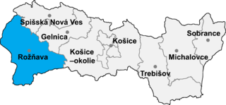
- map of the Košice region (Košický kraj) in Slovakia, district (okres) of Rožňava highlighted
- selfprovided on September 20th, 2004

|
Es ist erlaubt, die Datei unter den Bedingungen der GNU-Lizenz für freie Dokumentation, Version 1.2 oder einer späteren Version, veröffentlicht von der Free Software Foundation, zu kopieren, zu verbreiten und/oder zu modifizieren; es gibt keine unveränderlichen Abschnitte, keinen vorderen und keinen hinteren Umschlagtext.
Der vollständige Text der Lizenz ist im Kapitel GNU-Lizenz für freie Dokumentation verfügbar. |
| Diese Datei ist unter der Creative-Commons-Lizenz „Namensnennung – Weitergabe unter gleichen Bedingungen 3.0 nicht portiert“ lizenziert. | ||
| ||
| Diese Lizenzmarkierung wurde auf Grund der GFDL-Lizenzaktualisierung hinzugefügt. |
Dateiversionen
Klicke auf einen Zeitpunkt, um diese Version zu laden.
| Version vom | Vorschaubild | Maße | Benutzer | Kommentar | |
|---|---|---|---|---|---|
| aktuell | 17:46, 8. Jan. 2007 | | 3.071 × 1.432 (296 KB) | Murli | {{Information |Description= |Source= |Date= |Author= |Permission=Own work, all rights released (Public domain) |other_versions= }} {{PD-self}} |
| 21:36, 16. Mai 2005 |  | 365 × 184 (10 KB) | Murli | *map of the Košice region (Košický kraj) in Slovakia, district (okres) of Rožňava highlighted *selfprovided on September 20th, 2004 {{GFDL}} |
Dateiverwendung
Die folgenden 2 Seiten verwenden diese Datei:
Globale Dateiverwendung
Die nachfolgenden anderen Wikis verwenden diese Datei:
- Verwendung auf ar.wikipedia.org
- Verwendung auf be-tarask.wikipedia.org
- Verwendung auf be.wikipedia.org
- Verwendung auf ca.wikipedia.org
- Verwendung auf cs.wikipedia.org
- Verwendung auf da.wikipedia.org
- Verwendung auf en.wikipedia.org
- Ardovo
- Bohúňovo
- Bôrka
- Honce
- Drnava
- Čierna Lehota, Rožňava District
- Čoltovo
- Čučma
- Dlhá Ves
- Henckovce
- Gemerská Hôrka
- Hanková
- Gemerská Panica
- Gočaltovo
- Gočovo
- Hrušov, Rožňava District
- Jovice
- Jablonov nad Turňou
- Krásnohorská Dlhá Lúka
- Kečovo
- Koceľovce
- Kováčová, Rožňava District
- Kunova Teplica
- Kružná
- Lipovník, Rožňava District
- Markuška
- Meliata
- Nižná Slaná
- Ochtiná
- Pača
- Pašková
- Petrovo, Rožňava District
- Rakovnica
- Rejdová
- Rochovce
- Roštár
- Rozložná
- Silica, Rožňava District
- Silická Brezová
- Silická Jablonica
- Slavoška
- Vlachovo
- Vyšná Slaná
- Lúčka, Rožňava District
Weitere globale Verwendungen dieser Datei anschauen.