
Datei:D'Oyly Carte Island in 2001 from south (footbridge side) - geograph.org.uk - 128609.jpg
Zur Navigation springen
Zur Suche springen
Es ist keine höhere Auflösung vorhanden.
D'Oyly_Carte_Island_in_2001_from_south_(footbridge_side)_-_geograph.org.uk_-_128609.jpg (640 × 435 Pixel, Dateigröße: 199 KB, MIME-Typ: image/jpeg)
![]()
Diese Datei und die Informationen unter dem roten Trennstrich werden aus dem zentralen Medienarchiv Wikimedia Commons eingebunden.
![]()
_-_geograph.org.uk_-_128609.jpg?uselang=de)
Beschreibung
| Beschreibung |
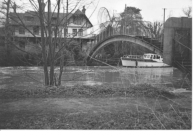
English: Desborough Cut, near Shepperton. The cottage is approached by a private, arched, metal bridge across the Desborough Cut. The cut is a short cut on the Thames for boat traffic, putting the cottage on D'Oyly Carte Island where Sir Arthur Sullivan's house is located. Boats, like this one, are moored for most of the year. |
| Datum | |
| Quelle | From geograph.org.uk |
| Urheber | Colin Smith |
| Namensnennung (von der Lizenz verlangt) | Colin Smith / Desborough Cut, near Shepperton. / |
| Kameraposition | | Dieses und weitere Bilder auf OpenStreetMap |
|---|
_-_geograph.org.uk_-_128609.jpg¶ms=051.382666_N_-000.454205_E_globe:Earth_type:camera__&language=de)
| Objektposition | | Dieses und weitere Bilder auf OpenStreetMap |
|---|
_-_geograph.org.uk_-_128609.jpg¶ms=051.382620_N_-000.454400_E_globe:Earth_class:object_type:object_source:geograph-osgb36(TQ07656597)_heading:45.00&language=de)
Lizenz

|
Dieses Bild stammt aus der Sammlung des Projektes „Geograph (Projekt)11“. Siehe die Seite der Fotografie für Kontaktinformationen. Das Urheberrecht dieses Bildes liegt bei Colin Smith und ist lizenziert unter der Creative Commons11 Namensnennung-Weitergabe unter gleichen Bedingungen-2.0-Lizenz.
|
Diese Datei ist unter der Creative-Commons-Lizenz „Namensnennung – Weitergabe unter gleichen Bedingungen 2.0 generisch“ (US-amerikanisch) lizenziert.
Namensnennung: Colin Smith
- Dieses Werk darf von dir
- verbreitet werden – vervielfältigt, verbreitet und öffentlich zugänglich gemacht werden
- neu zusammengestellt werden – abgewandelt und bearbeitet werden
- Zu den folgenden Bedingungen:
- Namensnennung – Du musst angemessene Urheber- und Rechteangaben machen, einen Link zur Lizenz beifügen und angeben, ob Änderungen vorgenommen wurden. Diese Angaben dürfen in jeder angemessenen Art und Weise gemacht werden, allerdings nicht so, dass der Eindruck entsteht, der Lizenzgeber unterstütze gerade dich oder deine Nutzung besonders.
- Weitergabe unter gleichen Bedingungen – Wenn du das Material wiedermischst, transformierst oder darauf aufbaust, musst du deine Beiträge unter der gleichen oder einer kompatiblen Lizenz wie das Original verbreiten.
Dateiversionen
Klicke auf einen Zeitpunkt, um diese Version zu laden.
| Version vom | Vorschaubild | Maße | Benutzer | Kommentar | |
|---|---|---|---|---|---|
| aktuell | 22:11, 26. Okt. 2013 | | 640 × 435 (199 KB) | Adam37 | {{Information |Description=Eyot House, |Source=https://commons.wikimedia.org/wiki/File:Desborough_Cut,_near_Shepperton._-_geograph.org.uk_-_128609.jpg |Date=26 October 2013 |source=From [http://www.geograph.org.uk/photo/128609 geograph.org.uk] |author... |
| 21:59, 26. Okt. 2013 |  | 640 × 435 (178 KB) | Adam37 | Due to the equipment/rendering the colouring is incorrect, even for a time of extreme flooding in 2001 when this was taken. It is very well shot however. The description is: Eyot House, D'Oyly Carte Island, Weybridge. | |
| 04:49, 31. Jan. 2010 |  | 640 × 435 (139 KB) | GeographBot | == {{int:filedesc}} == {{Information |description={{en|1=Desborough Cut, near Shepperton. The cottage is approached by a private, arched, metal bridge across the Desborough Cut. The cut is a short cut on the Thames for boat traffic, putting the cottage on |
Dateiverwendung
Die folgende Seite verwendet diese Datei:
_-_geograph.org.uk_-_128609.jpg)