
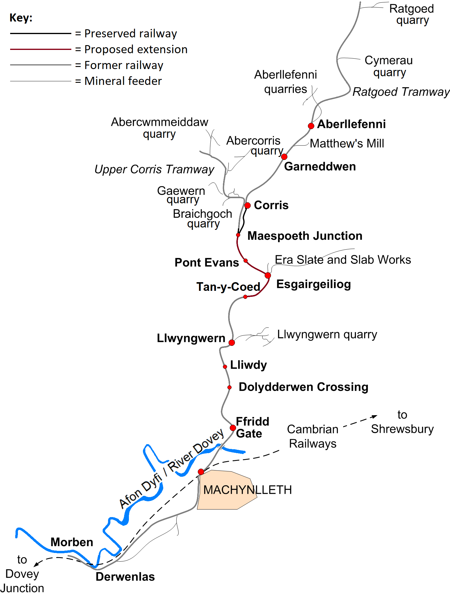
Datei:CorrisRailwayMap.png
Zur Navigation springen
Zur Suche springen
Größe dieser Vorschau: 453 × 599 Pixel. Weitere Auflösungen: 181 × 240 Pixel | 363 × 480 Pixel | 581 × 768 Pixel | 774 × 1.024 Pixel | 1.508 × 1.994 Pixel
Originaldatei (1.508 × 1.994 Pixel, Dateigröße: 229 KB, MIME-Typ: image/png)
![]()
Diese Datei und die Informationen unter dem roten Trennstrich werden aus dem zentralen Medienarchiv Wikimedia Commons eingebunden.
![]()
Beschreibung
| Beschreibung | |
| Datum | 15. September 2006 (Original-Hochladedatum) |
| Quelle | Die Autorenschaft wurde nicht in einer maschinell lesbaren Form angegeben. Es wird angenommen, dass es sich um ein eigenes Werk handelt (basierend auf den Rechteinhaber-Angaben). |
| Urheber | Die Autorenschaft wurde nicht in einer maschinell lesbaren Form angegeben. Es wird Dan Crow als Autor angenommen (basierend auf den Rechteinhaber-Angaben). |
Lizenz
Ich, der Urheber dieses Werkes, veröffentliche es unter der folgenden Lizenz:

|
Es ist erlaubt, die Datei unter den Bedingungen der GNU-Lizenz für freie Dokumentation, Version 1.2 oder einer späteren Version, veröffentlicht von der Free Software Foundation, zu kopieren, zu verbreiten und/oder zu modifizieren; es gibt keine unveränderlichen Abschnitte, keinen vorderen und keinen hinteren Umschlagtext.
Der vollständige Text der Lizenz ist im Kapitel GNU-Lizenz für freie Dokumentation verfügbar. |
| Diese Datei ist unter der Creative-Commons-Lizenz „Namensnennung – Weitergabe unter gleichen Bedingungen 3.0 nicht portiert“ lizenziert. | ||
| ||
| Diese Lizenzmarkierung wurde auf Grund der GFDL-Lizenzaktualisierung hinzugefügt. |
Dateiversionen
Klicke auf einen Zeitpunkt, um diese Version zu laden.
| Version vom | Vorschaubild | Maße | Benutzer | Kommentar | |
|---|---|---|---|---|---|
| aktuell | 19:37, 8. Dez. 2020 | | 1.508 × 1.994 (229 KB) | WT79 | transparentify background; better colour filling for railway; better station shapes |
| 21:37, 7. Dez. 2020 |  | 1.508 × 1.994 (231 KB) | WT79 | small icon for Maes-poeth, as it ''was'' an unofficial stopping place; colour railway line according to preservation status (and add key) | |
| 16:58, 26. Jun. 2020 |  | 1.508 × 1.994 (221 KB) | WT79 | added River Dovey | |
| 19:12, 25. Jun. 2020 |  | 1.508 × 1.994 (183 KB) | WT79 | Smaller icons for Pont Evans, Lliwdy, and Dolydderwen Crossing, as they were not official stopping places. Added 'quarry' after quarries. apostrophe in "Matthew's Mill". | |
| 16:19, 19. Sep. 2006 |  | 1.508 × 1.994 (161 KB) | Gwernol | Map of the Corris Railway Author: Dan Crow | |
| 22:55, 16. Sep. 2006 |  | 1.480 × 1.989 (157 KB) | Gwernol | Map of the Corris Railway Author: Dan Crow | |
| 15:47, 15. Sep. 2006 |  | 1.496 × 1.989 (140 KB) | Gwernol | {(Information |Description=Map of the Corris Railway |Date=15 September 2006 |Author=Dan Crow}} | |
| 15:28, 15. Sep. 2006 |  | 1.442 × 1.978 (136 KB) | Gwernol | {{Information |Description=Map of the Corris Railway |Date=15 September 2006 |Author=Dan Crow }} | |
| 15:02, 15. Sep. 2006 |  | 1.324 × 1.937 (102 KB) | Gwernol | Map of the Corris Railway Author: Dan Crow |
Dateiverwendung
Die folgende Seite verwendet diese Datei:
Globale Dateiverwendung
Die nachfolgenden anderen Wikis verwenden diese Datei:
- Verwendung auf cy.wikipedia.org
- Verwendung auf kw.wikipedia.org
- Verwendung auf www.wikidata.org