
Datei:Ancient tamilakam ports.png
Originaldatei (4.984 × 4.925 Pixel, Dateigröße: 9 MB, MIME-Typ: image/png)
![]()
Diese Datei und die Informationen unter dem roten Trennstrich werden aus dem zentralen Medienarchiv Wikimedia Commons eingebunden.
![]()
Beschreibung
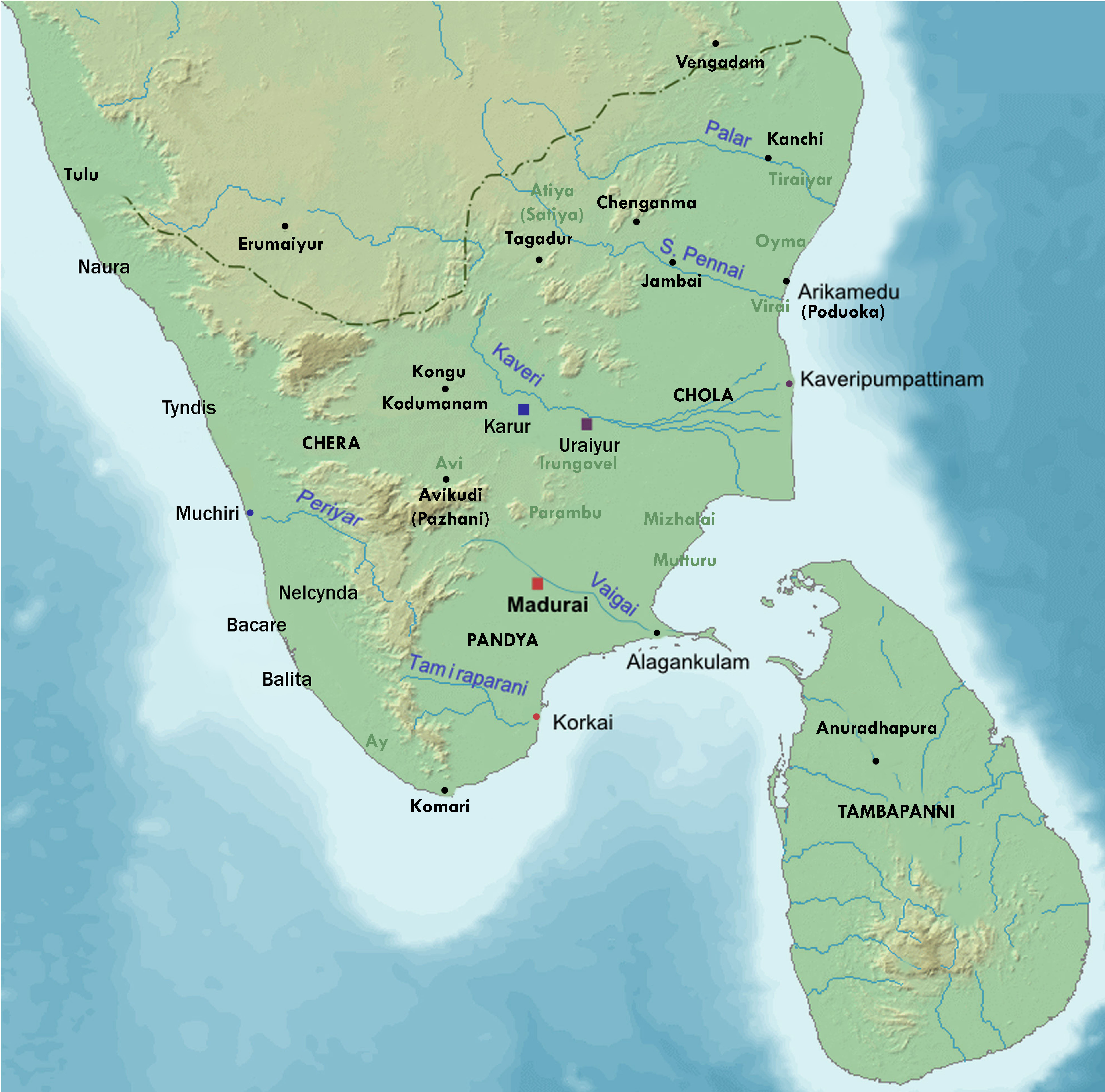
| Beschreibung | Map showing the important port cities of ancient Tamil country and its approximate northern boundary |
| Datum | |
| Quelle |
Source of map: http://www2.demis.nl/mapserver/mapper.asp (mention : "Disclaimer: With this statement DEMIS BV grants you permission to freely copy the PNG images returned by our server and use them for your own purposes, including web pages. We would appreciate a reference to our server but such a reference is not required, nor do we take responsibility for the accuracy or quality of the maps". at http://www2.demis.nl/mapserver/DataSrc.htm) Modified by me using Inkscape. |
| Urheber | Lotlil |
Lizenz
| Dieses Werk wurde von seinem Urheber I, Lotlil als gemeinfrei veröffentlicht. Dies gilt weltweit. In manchen Staaten könnte dies rechtlich nicht möglich sein. Sofern dies der Fall ist: I, Lotlil gewährt jedem das bedingungslose Recht, dieses Werk für jedweden Zweck zu nutzen, es sei denn, Bedingungen sind gesetzlich erforderlich. |
Dateiversionen
Klicke auf einen Zeitpunkt, um diese Version zu laden.
| Version vom | Vorschaubild | Maße | Benutzer | Kommentar | |
|---|---|---|---|---|---|
| aktuell | 09:24, 29. Nov. 2019 | | 4.984 × 4.925 (9 MB) | StephenPaa | Added more locations |
| 11:41, 29. Aug. 2019 |  | 2.000 × 2.000 (2,61 MB) | StephenPaa | Added Karur | |
| 10:57, 29. Aug. 2019 |  | 2.000 × 2.000 (2,61 MB) | StephenPaa | Corrected the colour of some ports and the Chera country | |
| 06:49, 7. Aug. 2007 |  | 800 × 800 (385 KB) | Lotlil | {{Information |Description=Map showing the important port cities of ancient Tamil country and its approximate northern boundary |Source=Source of map: http://www2.demis.nl/mapserver/mapper.asp (mention : "Disclaimer: With this statement DEMIS BV grants yo | |
| 06:41, 7. Aug. 2007 |  | 800 × 800 (385 KB) | Lotlil | {{Information |Description=Map showing the important port cities of ancient Tamil country and its approximate northern boundary |Source=Source of map: http://www2.demis.nl/mapserver/mapper.asp (mention : "Disclaimer: With this statement DEMIS BV grants yo |
Dateiverwendung
Die folgende Seite verwendet diese Datei:
Globale Dateiverwendung
Die nachfolgenden anderen Wikis verwenden diese Datei:
- Verwendung auf ar.wikipedia.org
- Verwendung auf en.wikipedia.org
- Verwendung auf hu.wikipedia.org
- Verwendung auf ko.wikipedia.org
- Verwendung auf ta.wikipedia.org