
Datei:2009-09-29 Samoa Island Region earthquake location.jpg
Zur Navigation springen
Zur Suche springen
Es ist keine höhere Auflösung vorhanden.
2009-09-29_Samoa_Island_Region_earthquake_location.jpg (420 × 468 Pixel, Dateigröße: 57 KB, MIME-Typ: image/jpeg)
![]()
Diese Datei und die Informationen unter dem roten Trennstrich werden aus dem zentralen Medienarchiv Wikimedia Commons eingebunden.
![]()


Beschreibung
| Beschreibung |
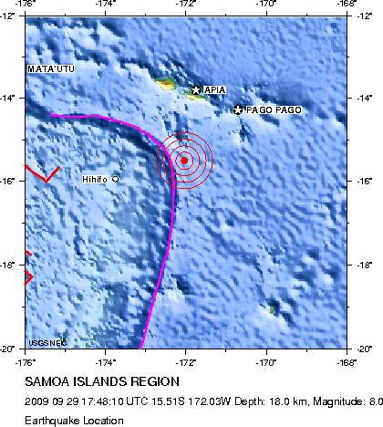
English: Earthquake location map. Major Tectonic Boundaries: Subduction Zones -purple, Ridges -red and Transform Faults -green
Deutsch: Erdbebenlagekarte. |
| Datum | |
| Quelle | http://neic.usgs.gov/neis/eq_depot/2009/eq_090929_mdbi/neic_mdbi_l.html |
| Urheber | United States Geological Survey |
Lizenz
Dieses Bild ist Gemeinfreiheit11 (public domain), weil es Materialien beeinhaltet, die ursprünglich vom United States Geological Survey11, einer Behörde des Innenministerium der Vereinigten Staaten11, stammen. Weitere Informationen finden Sie in den Urheberrechtsbestimmungen des USGS
|
Dateiversionen
Klicke auf einen Zeitpunkt, um diese Version zu laden.
| Version vom | Vorschaubild | Maße | Benutzer | Kommentar | |
|---|---|---|---|---|---|
| aktuell | 17:05, 1. Okt. 2009 | | 420 × 468 (57 KB) | Avenue | Updated version from USGS website: http://neic.usgs.gov/neis/eq_depot/2009/eq_090929_mdbi/neic_mdbi.jpg Created by USGS, so public domain. |
| 22:52, 29. Sep. 2009 |  | 420 × 468 (57 KB) | Matthiasb | {{Information |Description={{en|1=Earthquake location map. Major Tectonic Boundaries: Subduction Zones -purple, Ridges -red and Transform Faults -green}} {{de|1=Erdbebenlagekarte. }} |Source=http://neic.usgs.gov/neis/eq_depot/2009/eq_090929_mdbi/neic_mdbi |
Dateiverwendung
Die folgende Seite verwendet diese Datei:
Globale Dateiverwendung
Die nachfolgenden anderen Wikis verwenden diese Datei:
- Verwendung auf de.wikinews.org
- Verwendung auf en.wikinews.org
- Verwendung auf es.wikipedia.org
- Verwendung auf es.wikinews.org
- Verwendung auf eu.wikipedia.org
- Verwendung auf fi.wikipedia.org
- Verwendung auf fr.wikipedia.org
- Verwendung auf he.wikipedia.org
- Verwendung auf hif.wikipedia.org
- Verwendung auf it.wikipedia.org
- Verwendung auf ja.wikipedia.org
- Verwendung auf ms.wikipedia.org
- Verwendung auf nl.wikipedia.org
- Verwendung auf no.wikipedia.org
- Verwendung auf pl.wikipedia.org
- Verwendung auf pl.wikinews.org
- Verwendung auf pt.wikipedia.org
- Verwendung auf pt.wikinews.org
- Verwendung auf ro.wikipedia.org
- Verwendung auf th.wikipedia.org
- Verwendung auf www.wikidata.org
- Verwendung auf zh.wikipedia.org